Park areas in Pirin Mountain
On the territory of one of the most amazing national natural parks in the country – Pirin Park, there are six park regions that are as beautiful and exciting the imagination.
Now we would like to introduce you to these regions in Pirin Mountain, and we hope that it will be helpful to you if you decide to explore Pirin Mountain in details.
Vihren
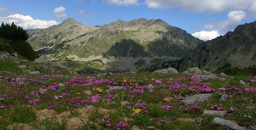
We will start with the Vihren park area because it is the most accessible of all the park areas in Pirin. On the territory of Vihren region are located the cirques of several lakes and lake complexes – the Fish Lake, Hvoinoto Lake, Vlasishkite Lakes, Tipitskite Lakes, the Long Lake.
Damyanitsa and Banderitsa rivers also pass through the park area, and here you can see one of the biggest natural sights not only in Pirin, but also in Bulgaria – Baikushev‘s pine. Considering the fact that within the borders of this area is located one of the most popular and beautiful peaks in Pirin – Vihren peak, now you know why we started our tour of the regions of Pirin from Vihren area.
Routes in Vihren park area
Thanks to its proximity to Bansko (where the central office of the area is located), Vihren region is urbanized and offers many tourist routes with different degree of difficulty. We will mention some of the most popular routes and then the choice is yours.
Bansko – Baikushev’s pine
The distance from the resort town to Baikushev’s pine is only 15 kilometers and to overcome it you do not have to do any mountain feats. You can reach the natural landmark by car, so you will not even sweat.
But if you decide to move around, then the walk from Bansko to Baikushev’s pine will take less than 3 hours, and the difficulty of the road is so insignificant that you will not even notice how you have walked the 15 kilometers.
Bansko – Banderitsa hut
Once you have reached Baikushev’s pine, you can go further up in the mountain (about 300 meters if we have to be exact) and you will get to Banderitsa hut. And there is another great route for exploration of Vihren park area. If you have energy left, you can go and see Banderitsa waterfall while you are still in the region of Banderitsa hut, as the waterfall is located close to the hut.
And now the best thing… If you are not a fan of walking, but you wish to enjoy all these beautiful sights, you can just use one of the buses that leave from the town of Bansko and reach the hut and Baikushev’s pine.
Bansko – Demyanitsa River –Demyanitsa hut
This route will not cause you any trouble. The trail „Demyanitsa River tells” starts a bit above Bansko, passes along the river, where you can recharge near not one, but two beautiful waterfalls – Demyanishki and Ulenski skok. If the walk seems too short, then you can continue walking to Demyanitsa hut.
Bansko – Vihren peak
You will best appreciate the beauty of Vihren park area if you go uphill to the top. Several tourist trails of different difficulty lead to Vihren peak. One of the routes starts from Banderitsa hut, the other starts from Vihren hut. You can reach the peak also from Yavorov hut, which is located in the town of Razlog, which is situated a few hours away from the town of Bansko.
Bezbog
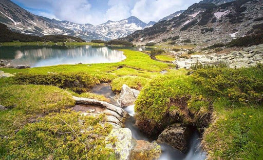
Bezbog is also a participant in the park area, its central office is situated (absolutely logically) in Dobrinishte. The region includes areas of one of the most beautiful reserves in Pirin park – „Ulen”, as well as Bezbog peak, Popovo Lake (the largest lake in Pirin), Polezhan peak, Bezbozhko Lake, the cirques Kremenski, Ribni, Kamenishki and Samodivski Lakes. There are more than 700 higher plants growing in the area, a large part of which are listed in the Red book.
Routes to explore the Bezbog park area
The starting point of almost all hiking trails is the lift, which starts above Dobrinishte and reaches Bezbog hut.
If it is enough for you to admire the beauty of the section from above, you can just get on the lift and go to Bezbog hut, where you can drink tea and then go back.
Or you can choose one of the tourist routes that leave from here.
Bezbog hut – Popovo Lake
This route is relatively easy, and if you follow the marking and walk at a normal speed, you will reach the lake in an hour and a half. Popovoto Lake, as mentioned above, is the largest lake in Pirin and a wak there will sure appeal to you.
We almost forgot. If you decide to go on this route, you will see not one, but two lakes, because the path will take you fist to Bezbozhko Lake (which is located behind the hut), and at the end of the destination you will get to Popovoto Lake.
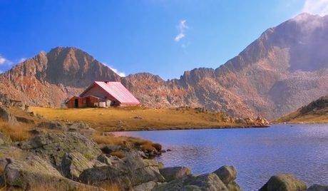
Bezbog hut – Tevno Lake shelter
This route is much heavier than the previous one, but if you are well prepared and you decide to choose it, we guarantee you will not regret it. The places you will see are uniquely beautiful and worth seeing. You will need about 4 hours to reach Tevno Lake.
Three rivers
Three rivers is one of the most amazing and beautiful regions in Pirin Mountain. It is located to the north of Bezbog park region, to the west of Kamenitsa park region, to the south of Katuntsi forestry and to the east of Gotse Delchev forestry. In the zone of the park area can be seen large forest massifs of white fir, beech, spruce, fir and others. „Pirin”hut is located here, as it is one of the most beautiful mountain huts, which is very popular among the mountaineers.
The waters of three Pirin rivers gather in the lands of the park region – Demirkapiiska, Kelyava and Sredna Rivers, so this explains the name of the region.
There are several routes to explore the Three rivers park area, as one of the most popular are:
- Starting point Pirin hut – Mitrovo Lake – end point Tevno Lake
- Starting point Pirin hut – Argirovo Lake – Popovo Lake – end point Bezbog hut
- Starting point Pirin hut – Kelyava River – end point Berkovitsa hut
- Starting point Pirin hut – Lopovo – Rozhen village – end point the town of Melnik
Almost all the routes in the park section have a starting point from the Pirin village. The difficulty of the routes is different, so it is a good idea to choose a specific route and get to know it better, so you can overcome it easily.
Sinanitsa
Sinanitsa is just as amazing as the other park regions in Pirin. The section is located between park area Bayuvi dupki (to the north), Vihren park region (to the east), Kamenitsa park region (to the south), and to the west it borders with Kresna, Simitli and Strumyani gorge.
Within the area of Sinanitsa are located the Vlahinski, Sinanishki and Georgiiski cirques, as well as the magnificent Sinanitsa peak and Muratov peak are rising here, and the flora and fauna are so diverse that you will feel as if you are in a fairytale.
Routes that you can choose
Only two tourist routes pass through the territory of Sinanitsa park region, and the starting point is Mandrata area. The first route starts from Mandrata area, it passes through Sinanitsa hut and reaches Pirin hut. The second route has yellow marking and also starts from Mandrata area, then it passes through Chernata voda and reaches Yavorov hut.
There is only one hut in the zone of the park region – Sinanitsa hut.
Kamenitsa
The section is bordered by the park regions Three rivers, Sinanitsa and Vihren, and to the south its borders reach Sandanski state forestry (where you can find its central office).
On the territory of the park region are located the incredibly beautiful Tevno Lake and Kuklensko Lake, as well as the Bashliiski, Chairski, Mozgovishki, Spanopolski Lakes. Several peaks rising here, as the highest and most popular one is Kamenitsa peak.
There are several huts and shelters built in the section, as the most populat tourist destinations are Tevno Lake shelter, Berkovitsa hut and Spano pole shelter. The tourist routes in this park region of Pirin are also very pleasant, as the most preferred by the tourists are:
- Sandanski hut – Spano pole shelter – Vihren hut
- Sandanski hut – Berkovitsa hut – Demyanitsa hut
- Sinanitsa hut – Spano pole shelter – Berkovitsa hut – Pirin hut
Bayuvi dupki
„Bayuvi dupki – Dzhindzhiritsa reserve is also within the territory of Pirin park region. Moreover, the region has common areas with the municipalities of Simitli and Razlog. It all comes to show that this park area can offer you not only incredibly beautiful views, but also you can enjoy its magnificent forests, the variety of plants, mammals and birds while you walk through its mountain trails.
If you decide to visit this park area, you have plenty of opportunities to do it, because many hiking trails are passing through it.
The international tourist route E4: Pyrenees – Alps- Rila – Pirin- Peloponnese passes here, which attracts thousands of mountaineers all year round, who have decided to test their strength and endurance by walking this long walking route.
If you decide to try the international tourist route E4, its Pirin area starts from Predel hut, then it passes through Yavorov hut, Vihren hut, reaches the Tevno Lake shelter and Pirin hut and ends at Popovi meadows.
Another very popular tourist route, which you can try, starts from the town of Razlog, then it passes through the Betlovoto area and Yavorov hut, and from there it passes through the Suhodolski ridge and ends in Kresna.