Todorka Peak – the Legendary Giant in the North Pirin Mountain
If you are heading towards the mountain town of Bansko in Bulgaria, you are about to experience a legendary trip throughout every season of the year. The region of Bansko is world famous for its breathtaking sceneries, exciting ski runs, and unique historical and ethnographic sights of national importance.
In the heart of the Pirin Mountains, you will find several ski tracks for winter sports, most of which host different world cup races. Meanwhile, the cloudless days of summer are perfect for choosing a scenic hiking route between lakes, peaks, and romantic mountain huts.
Vihren is the highest peak in the mountains around Bansko, but is far from the only peak worth a climb. So today, we are taking you on an adventurous hike to the Todorka Peak – one of the special gems in the Bansko ski area.
Interesting Facts about Todorka Peak
Todorin peak, also known as Todorka or Big Todorin peak, is a large granite peak in North Pirin Mountain. It is the highest peak on the Todorino side ridge and is situated on the ridge of the same name. It has a rocky structure and is built entirely of granite. In some places, you can see grassy areas.
At Vasilishki chukar, the ridge is divided by the Main Pirin crest and expands to the northeast. To the south, its slopes reach the Banderishki cirque, and to the north, they reach the Banderritsa River.
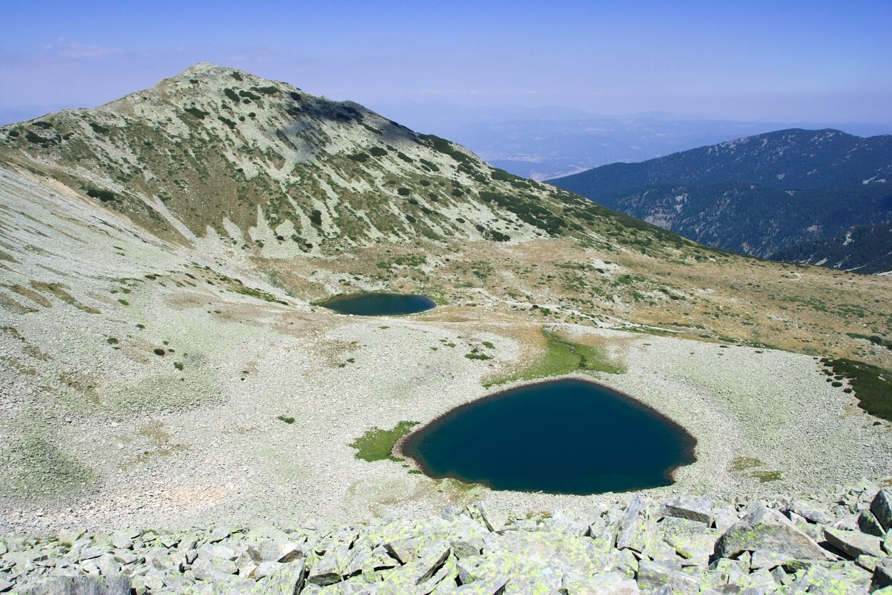
To the east, its slopes form a small cirque, which houses the Todorini Lakes. This cirque is the second in height after the Vasilishki cirque, where the Vasilishki Lakes are located.
As it is 2746 m above sea level, Todorka Peak ranks among the 11 highest peaks in Pirin Mountain. But neither the side ridge nor the summit elevation is the most impressive thing about it.
Instead, there is a magnificent view from the peak, revealing the nearby lakes called The Eyes of Todorka or Todorini eyes, as the name is associated with a legend. The Premkata saddle separates Todorka peak and Vasilishki chukar.
Todorka peak has very steep slopes, which are covered with rock blocks to the northeast. In shape, it is a massive truncated pyramid with three high points or three peaks. This relatively short crest forms what mountaineers often call Big, Medium, and Small Todorka.
Big Todorka’s dramatic pyramid is the highest point, or the massive peak of Golyama Todorka. It is followed by two other peaks – Medium Todorka (Sredna Todorka) with 2708m and Small Todorka (Malka Todorka) with 2693m.
The highest point of the peak is located in the north. Its impressive pyramidal shape can be seen from Bansko. The edge of the ridge of Todorin peak extends to the southwest and reaches an elevation of 2706 m. Then it deviates to the southeast to an elevation of 2712 m.
Several ski runs are built on its slopes, and the ski tracks are developed extensively under the most modern European standards.
Last but not least – the Todorka side ridge is a well-known photographer hotspot, offering an impressive panorama of the Vihren summit and the beautiful lakes of Pirin.

To the east of the peak, you can visit two lakes in a cirque. These are the two Todorini Lakes, also known as Todorini eyes or Todora’s eyes.
Behind them passes the route from Vihren hut to Demyanitsa hut, which is well marked. To the west and the south is located the Banderishka valley, whose shape follows the slopes of the Todorin peak.
In some places of Banderitsa valley and Todorka peak, you can see the huge ski runs of the Bansko ski resort. Thanks to these, Bansko is one of the most famous resorts worldwide.
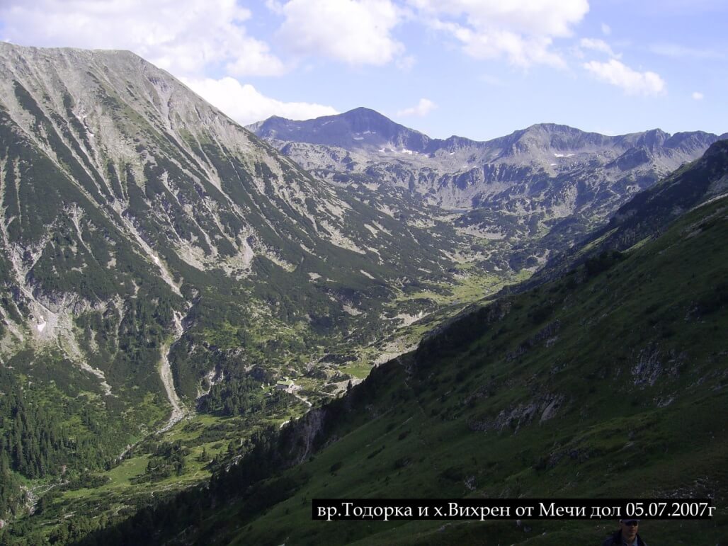
From Todorka peak, you can enjoy the beautiful scenery to the peaks Vihren and Kutelo to the west and Ushitsite to the east. To the south, you can see the Kamenitsa peak, and to the north, if the weather is clear, you can see Bansko so well that you can distinguish the streets and buildings.
Todorka peak reveals its magnificent beauty if observed from the Hvoinati peak and the Vihren peak, with a surface covered with wavy gullies due to avalanches. If observed from the south in the direction of Banderiski chukar, the Todorka peak looks like a trapezoid in shape.
The view from the north: the Razlog hollow, however, is the most magnificent. From there, the peak looks like a sharpened pyramid, separated by a big valley from the Vihren peak.
If we look at Todorka peak from the Polezhanski Ridge, it will look like a long hill facing the west with its most exposed part. This long ridge has a length of 1400m, and exactly on it are located all three heights – Big, Medium, and Small Todorka. They can be seen very well from the shores of Muratovo Lake and Kaimakchal peak.
This place is preferred by fans of the summer season who like climbing adventures. However, it is important to mention that climbing this terrain requires good physical training and motivation.
Between Karamski chal to the northeast and Todorka peak to the northwest is a denudation surface. It is called Ovcha Polyana (Sheep’s meadow) and is situated on the rising ground which separates both cirques Karama and Vasilak. The name comes from the large herds of sheep bred here in the past.
The foot of Todorka peak is in the Shilingarnika area, a starting point of the lifts. It is situated along the route from the town of Bansko to Vihren hut. There is an Upper and Lower Shilingarnik. The name of the area comes from the fact that lambs have spent the night here in the past.
The Legend of Todorka Peak 
The name of Todorka peak, as well as the names of the nearby lakes, are associated with two legends.
According to the first legend, the bold Bulgarian girl Todorka took part in defense of the Sitan fortress. To her last breath, the girl fought the Turkish invaders and chose to die before accepting the foreign faith.
The legend has different interpretations. In one of them, there is a man called Murat Bey, and Muratov peak is named after him.
While the Turks followed Todorka, and she didn’t want to be caught by them, she climbed to the top of the fortress. Then she jumped from it and died.
The second legend tells a story about a local girl called Todorka, who could not convince her father to give her to her beloved Vasil (or Vasiliki). So Todorka left her father’s house and climbed the high hill.
When she reached the top, she started crying. As a result, her teardrops formed the two lakes Todorini Lakes (also known as Todorini teardrops). Viewed from above, each lake truly looks like an eye or a teardrop.
Her beloved Vasil had been looking for her for a long time. So he reached Vasilashki chukar peak, and because he was so frustrated, he jumped into the lake above the peak (one of the Vasilishki Lakes or the Vasilashki lakes).
In another version of the second legend, Todorka is the beloved woman or the sister of the shepherd Vasil. The story tells that her beloved Vasil cried a lot because she made him suffer, so the Todorini Eyes Lakes were formed that way.
Some other than these two legends tell that Murat bey, who gave the name of Muratov peak, had kidnapped Todorka, which brought the sorrow of the shepherd Vasil.
How to Get There?
You can easily climb the Todorka peak from the Premkata saddle (also called Todorina gate or Todorina porta) to the south of the peak. There the displacement to the top elevation is only 170m, and also from the north, from the Shiligarnika.
This is the only rocky place on the top. It is a narrow pinnacle that connects the upper stations of the lifts with the peak. Another option is to follow the route from Vihren hut to Demyanitsa hut.
When we reach Vihren hut, we are already closer to the mountain. Here we don’t need vehicles. If we start climbing from Vihren hut, we will follow the route to the foot of Todorina gate, which overlaps with the trail that leads to Todorka peak.
The chosen path has varied terrain – it requires climbing, but there are some flat sections. From here, you can enjoy a dramatic view with a beautiful 360-degree panorama.
To get to Todorka peak, we must follow the path from Vihren hut. At the foot of the ridge, there’s a climbing path that leads to Demyanitsa hut. Although the track is flat in some places, the elevation is progressive, and we will feel the slopes becoming steeper.
On our way, we will see several lakes. One of them has the curious name Zhabeskoto lake (the frog lake), which is called this way because many frogs live in it. After we pass it, we can start the actual climbing to Todorka peak.
The route goes only upwards and zigzags up towards the location of the peak. It is relatively easy to pass, though its peculiar twist makes it full of unexpected sights around each turn.
At some point, the route direction will head towards Small and Medium Todorka, which hikers have to pass. This will take about an hour because the path is filled with stony hills, so we have to be careful.
With every step we take, the scenery becomes more impressive, and the valley lies invisible far in the distance. When the weather is clear, we can see one of the champions of Pirin Mountain – Vihren peak and Kutelo peak.
If we turn to the other side, we can enjoy the peaks Kamenitsa, Polezhan, and Strazhite. The other places we can see are Vihren hut and the two beautiful Todorini Lakes.
Reaching 2746 m above sea level will take us about 4 hours in one direction. Because we will spend a lot of time outdoors in nature, it is advisable to bring food, water, and warm and comfortable clothes.
To descend from the Todorka peak, hikers can take its southern ridge or northern side. You can spend the night in the Vihren hut or simply climb all the way down to Bansko and choose the best hotel to fully relax after the experience.