Rivers in Pirin Mountain
If we now ask you which are the highest peaks, the most beautiful lakes or the most popular resorts in Pirin Mountain, we are sure that you will almost immediately think of at least half of them. However, when it comes to the rivers in Pirin Mountain, the stiuation slightly changes, as they are rather underestimated as a tourist destination, and this seems a little unfair.
Because Pirin is a mountain blessed not only with numerous lakes and lake complexes but also with many rivers, beautiful waterfalls and cascades.
Do you want to learn a little bit more about the rivers in Pirin Mountain?
Then let’s not waste time, but start our walk.
Before we introduce you to the main rivers that rise from Pirin Mountain, we will make it clear that all rivers that start from this mountain flow into Struma River or in Mesta River.
The more important rivers flowing into Mesta River are:
- Glazne (formed by the Banderitsa and Demyanitsa rivers)
- Disilitsa (with main tributary Pleshka River)
- Bezbozhka River
Glazne
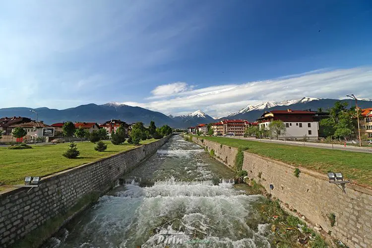
Anyone who has visited the town of Bansko at least once has seen the Glazne River, because it passes through the entire town from south to north. The river has a length of 24.6 kilometers, which does not make it a long river, but it is one of the most deep rivers flowing on the territory of Pirin Mountain.
Glazne is formed by the conflux of two other Pirin rivers – Demyanitsa and Banderitsa, which join slightly above Bansko. Once they join together they form Glazne, as the river passes through the entire town and through the Razlog valley in the direction of the village of Banya, after which it flows into the Iztok River, which is a tributary of Mesta River.
Most probably the name of the river comes from the Slavic word „glaz”, which means „round, spherical stone”. Its name is very suitable, because if you are in the region of Bansko and walk along the banks of Glazne you will notice that the stones in it are round and very smooth.
Since Glazne is a relatively short and quite calm river, it is not suitable for rafting or other type of water sports, but it is a wonderful place if you want to organize a picnic in nature. There are many hidden places with small cascades along its stream, which are the perfect place to cool off or have a delicious meal in the peaceful atmosphere of the mountain.
Banderitsa
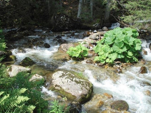
As we mentioned above, Banderitsa is one of the rivers that form Glazne. The river rises from the Upper Banderishko Lake, gathers the waters of all other Banderishki Lakes and descends steeply to flow into the Glazne River.
Banderitsa is only 13 kilometers long, but as it descends under a significant slope it is quite rough and forms numerous picturesque waterfalls and cascades. One of the most beautiful and deep waterfalls in Pirin Mountain is located right in Banderitsa. The waterfall is called Banderishki skok and has a height of 11 meters. The region around the waterfall was declared a protected area in 1965.
The Banderitsa River is very picturesque and if you want to enjoy it, you can make a one-day trip from Bansko to Banderitsa hut.
Demyanitsa
The Demyanitsa River gathers the waters of several lake complexes. Initially, it runs to the west, then passes through the Tiyatsite area and heads north. After the Demyanitsa hut, two tributaries flow into the river, which makes it quite deep.
Since the Banderitsa River runs under a significant slope, it forms two beautiful waterfalls just under the Demyanitsa hut – Demyanishki skok waterfall (11 meters) and Ulenski skok waterfall (9 meters). The way of the river continues to Bansko, and just over the town it makes a conflux with Banderitsa River, and they form Glazne River and you know the rest…
Demyanitsa has a length of 13 kilometers, but this does not prevent it from being one of the most preferred rivers for walks in nature. One of the most popular routesthat start from Bansko is right along the river valley of Demyanitsa. The route passes by the two waterfalls of the river, continues along the river valley and reaches Demyanitsa hut.
Disilitsa
Disilitsa River rises from the Disilishko Lake, which is located at an altitude of 2367 meters at the foot of the Polezhanski cirque. The river flows independently for 10 kilometers, then it makes a conflux with the Pleshka River that rises from the Plesko Lake.
After the conflux with its main tributary, the river flows to the north – northeast through valleys and forests and reaches Dobrinishte. It passes through the eastern part of the town, then it turns east and after 5 kilometers it flows into the Mesta River.
Disilitsa has a length of 21 kilometers and is also called Dobrinishka River, because this is the only town through which it passes.
Bezbozhka River
Bezbozhka River rises from the Bezbozhko Lake, which is located under the Bezbog peak in Norther Pirin Mountain. The river has a length of 16 kilometers, it is located at an altitude of 1375 meters and runs to the northeast to flow into the Mesta River at the Lushin area.
Although it is a rather short river, the Bezbozhka River passes through very beautiful forests and is a wonderful place for picnics and fishing. In the summer it is rich in Balkan trout, and often local people organize river fishing competitions along its river valley.
We forgot to mention that Bezbozhka River is also known as Duilovitsa River.
These and other smaller rivers in Pirin Mountain, flow into the Mesta River. The river rises from Rila Mountain, then passes through the territories of Bulgaria and Greece and flows into the Aegean Sea near the Greek island of Kavala.
The Mesta River has a length of 273 kilometers, as 126 kilometers are on Bulgarian territory, which ranks it on the 20th position in terms of length among the Bulgarian rivers.
The rivers that flow into Struma River are Vlahina River, Sandanska Bistritsa, Pirin Bistritsa and Melnishka River.
Pirin Bistritsa River
The Pirin Bistritsa River is the longest river that rises from Pirin Mountain and it flows into the Struma River. Its length is 53 kilometers, which ranks it at the 80th position among the Bulgarian rivers.
Pirin Bistritsa rises from the southern part of Argirovoto Lake, which is located at an altitude of 2356 meters in the Demirkapiiski cirque in North Pirin Mountain. Initially, the river flows to the south, then makes a turn to the southeast at „Pirin”hut, passes through valleys and enters the Petritch- Sandanski valley.
Just before the Novo Hadjovo village, Petrovska River, which is the biggest tributary of Pirin Bistritsa, flows into it, and after another 7 kilometers it passes the Bulgarian-Greek border to flow into the Struma River at the Promahon village.
There is an Electro power plant built on the Bulgarian territory along the stream of Pirin Bistritsa, which supplies with energy the settlements located in the area.
Fans of fishing often visit the river, because it is planted with barbell and trout.
Vlahina River
Vlahina or Vlahinska River rises from the highest and biggest Lake of all Vlahinski Lakes, which are located in the Vlahinski cirque under the Vihren peak. Initially, the river flows through an ice valley, then surrounds the Gredaro ridge, continues to the west, passes near the Vlahi village and about 300 meters from the town of Kresna flows into the Struma River.
The river has a total length of 27 kilometers and during the summer months it is not very deep, but in spring, when snow melts, the amount of water can increase significantly.
Sandanska Bistritsa
Sandanska Bistritsa, also called Bistritsa River and Svetivratchka Bistritsa, rises from Tevno Lake, which is located in the Belmeto cirque in the northern part of Pirin Mountain. At the very beginning of its journey, the river gathers the waters of Malokamenishki Lakes and then heads west where its first tributary – Bashliitsa River, flows in it. Then it makes a turn southwest, passes through Tremoshtnitsa area, where the other tributaries flow into it – these are the Tremosnitsa and Razslankovitsa Rivers. Shortly thereafter, Sandanska Bistritsa reaches the town of Sandanski and flows into the Struma River.
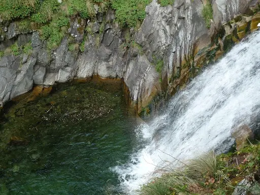
The river has a length of 33 kilometers and is one of the most beautiful rivers in Pirin Mountain. In its upper part is located one of the biggest waterfalls in Pirin – Popinlashki waterfall, as its waters fall from 15 meters.
Along the river valley of Sandanska Bistritsa are located the popular resort areas of Popina Luka and Tremoshtnitsa, and you can get there by car. Near the Popinlashki waterfall is located the Yane Sandanski hut, which makes the river valley a great place for walks, tourist hikes and picnic area among the beauty of Pirin Mountain.
Melnishka River
The Melnishka River is formed by the conflux of two rivers – Sugarevska and Dolenska Rivers. Its right tributary – Dolenska River, is considered the beginning of its journey, as it rises under the Kelio peak in the north part of Pirin. Just above the town of Melnik, Dolenska River meets Sugarevska River, and both rivers form the Melnishka River. The river has a length of 30 kilometers, and on its way to Struma River it flows in the south – southwest direction.
The beautiful Melnik Earth Pyramids that amaze us today, have formed thanks to the Melnishka River. In the summer, the waters of the river often disappear underground, but during the rainy season or when snow melts, the level of Melnishka River can increase dramatically, which makes it quite dangerous.
The river passes by the town of Melnik, then continues to the village of Zornitsa, enters the Petritch – Sandanski valley, turns south and flows into the Struma River about 2 kilometers away from the village of Marikostinovo.
Struma River
The Struma River has a length of 415.2 kilometers, as 290 kilometers of are flowing on the territory of our country, which ranks it sixth in length among the Bulgarian rivers. The river rises at about 250 meters under Cherni vruh peak in Vitosha Mountain, then it passes through the Pernik valley, enters the Chardakski gorge, then enters Radomir valley and Kyustendil valley, passes through the Skrinski gorge, and at Boboshevo exits the gorge and enters the Dupnitsa valley. Before it crosses the Greek border, the river crosses many other gorges and valleys, enters Rila, Pirin and Slavyanka.